Monday, January 27, 2025

January 27

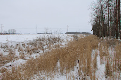
The mid-day weather is windy, cloudy and cold (around 20 degrees) as I stand on the Blair Rd bridge looking east at the frozen, snow-covered, 10-ft wide county drain, a redirected channel of the Bad River. Leaving the road, I head east along a high bank where I’m pleased to see a wide buffer zone protecting the watercourse. Along the way, I spot the dead seed heads of Blue Vervain and think about its lovely blossoms in summer (stock photo). Nearby, I spot the snowcapped seedheads of Burdock and Teasel, swaying in the wind. Proceeding east, I pass a small cattail marsh displaying a large muskrat lodge. Muskrats that occupy these structures will likely remain in them throughout the winter. Just ahead in open cropland, I come upon a set of muskrat tracks leading to and from a hole where the rodent had been digging for something to eat. Looking around, I’m surprised to see it still digging, so I approach before it skedaddles toward the river. Muskrats don’t hibernate and remain somewhat active in winter. However, since they are most active at night and twilight, I’m surprised to see this one out and about. I suspect it came from an underground den dug into the nearby riverbank that includes an underwater entrance covered with ice.  When I return to the riverbank and continue east, I hike adjacent to an 8-acre woodlot containing a mix of mature evergreen and broadleaf trees, while at my feet I spot Coyote tracks in the snow. Up ahead, I notice some dried seedpods of Moth Mullein and think about its lovely blossoms in summer (stock photo). Turning away from the river and entering the woodlot, I come upon another graveyard of large Ash trees strewn on the ground after being killed by the Emerald Ash Borer. Examining these downed logs more closely, I observe one covered with green and orange lichens and another with a single patch of Whitewash lichen. Looking up, I catch a glimpse of a cone and needles of Austrian Pine, a Red Pine look-a-like. Following some squirrel tracks, I notice a recently excavated cache of stored food. The question of how exactly these critters remember the locations of their caches is still a matter of debate, but it is thought they have spatial memory that use landmarks like trees, stumps and bushes as references. Once they get close, their sense of smell allows them to hone in. These mammals are also highly aware of their surroundings while caching and may pretend to bury a nut or seed in one spot if they think they’re being watched and then secretly bury it elsewhere. After exiting the woodlot, I turn west and head back toward the car while passing a deer carcass. Trudging through the snow into a stiff west wind, I finally arrive at the bridge, retreat to the car, turn on the heat and head for home.

In coldness of winter she lies down

A blanket of snow covers her ground

In newness of spring she comes alive

Warms the earth so creatures survive

In greenness of summer she hits her stride

Her lush landscape where wildlife abide

In briskness of autumn she paints the leaves

Colors of the rainbow to show off her trees

Last year is gone. New year begun

Nature’s seasons pass one by one


D. DeGraaf
 

Monday, January 20, 2025

January 20

It’s noontime as I hike south on a railroad track covered with 4 inches of snow toward a bridge, for my third encounter with the Bad River. Temperatures are in the mid- 20’s under cloudy skies and a slight west wind as I reach the bridge, as the ice-covered watercourse flows under me. Looking upstream, I see the 10-ft wide, ice-covered channel was straightened years ago as part of the county drain system. Likewise, I see the narrow plant buffer zones on both banks are out of compliance with the required width for protecting the river water from tainted runoff from the adjoining cropland. To further compound the problem, I hike past a few naturally-eroding drainage ditches, perpendicular to the river channel, that have breached the buffer zone allowing water from the cropland to flow down the steep bank directly into the river. Trudging along the snow-covered bank, I pause to look down at the ice-covered water where I spot some Wild Turkey tracks encased in ice and snow. These birds are not migratory but they often wander to areas with larger trees and closed canopy for increased warmth and food sources. Nearby, I spot a 4-inch opening most likely made as a breathing hole for a muskrat. Further ahead, another opening catches my eye. Based on the surrounding deer tracks, I suspect this was made as their watering hole. Turning around and heading back to the railroad tracks, I stop to notice the tiny tracks and tunnel of a Meadow Vole (stock photo).  Voles, like many other mammals, stay active all winter long. However, instead of hoarding food in secret caches or hibernating after bulking up, this rodent changes from a solitary creature to a communal one. In summer, they are aggressively solitary and will defend their home range from other voles. But in the winter, they huddle together in communal nests. Up ahead, I come upon familiar tracks of an Eastern Cottontail rabbit. Not surprising nearby, I observe some pea-size rabbit scat. Called fecal pellets, these harder, drier orbs are the second of two types of scat. As herbivores, rabbits first defecate softer, greener pellets, called Caecotrops, that they eat and further digest before defecating the hard, brown ones. (stock photo). Nearing the railroad tracks, I stop to pick and sample a bright red hip from a Wild Rose vine. This time of year the hip is soft with a sweet, tart taste and large seeds that I spit out. Native Americans used these hips for food and medicine. They are a good source of vitamin C and were especially important in the winter when other vitamin-rich plants were scarce. 

An hour of hiking

Through nature’s domain

Wandering and wondering

In snowy terrain

An hour to focus

On life in the wild

Eyes wide open

Like a curious child

An hour to admire

All that surrounds me

To respect and revere

Whatever I see


D. DeGraaf

Monday, January 13, 2025

January 13

Under sunny skies and frigid temperatures in the mid-teens, I’m standing on the edge of Buchannan Rd, facing south to see the frozen surface of the Bad River. It’s late morning as I begin my 2nd encounter with this watercourse that I plan to follow downstream to its confluence with the Shiawassee River, near Saginaw. Proceeding along the bank, I immediately spot a large tree trunk covered with green lichens and dark blobs of dead jelly mushrooms that are amber-colored when alive in the summer. (stock photo). Down at the river’s edge, I notice a very thin layer of clear ice on the water surface along with some scattered white dendritic ice crystals. These tree-like structures form quickly in a time of rapid temperature change. Following a trail along the flood plain, it’s easy to tell that many of the surrounding trees are Boxelder with their trunks that stick out in all directions. After turning around to return to the car, I spot a couple of dead, snow-dusted Pheasant back mushrooms attached to a decomposed stump. Back in the car, I drive a short distance south on Croswell Rd., park and watch the ice-covered river continues its journey eastward. Exploring the flood plain, I come upon an opossum carcass displaying an 11-inch hairless tail. The interesting part of the tail is that it has a layer of bony plates (stock photo) that not only help to protect it but also strengthen it. Opossums hanging from tree branches by their tail is a myth started by people who have seen baby and juvenile opossums doing this. On the other hand, an adult opossum cannot hang for more than a few seconds. The tail is particularly useful because it can curl up and grip twigs and other materials for nest building (stock photo). Scanning the far bank, I first look at and listen to water slowly flowing out of a drain tile and then I spot a very narrow buffer strip between the exposed cropland and the river channel. Whether from surface runoff or drain tiles, excess nitrates and phosphates from a previous fertilizer application can pollute the river water. Cold river water can be particularly problematic because while the nutrients from the fertilizer might be locked in the ice or frozen soil during winter, when the water thaws and warms in spring, a large burst of nutrients becomes available, leading to rapid algal blooms and potential depletion of oxygen levels, harming aquatic life. Also, knowing that this river has a history of excess sedimentation, the ice cover acts as a barrier, hindering water flow and decreasing the ability to carry sediment particles. 

Great bird of prey

Wingspan wide

You ride the wind

Soar and glide

Perch alone

In a tree so tall

How do you spot

A mouse so small

Off you fly 

If I get near

Red tailed hawk

You I revere


D. DeGraaf

Monday, January 6, 2025

January 6

It’s mid-morning as I stand on Jerome Rd watching water from the Bad River flow rapidly through a large culvert under me and continue east in a county drain. The name of this watercourse comes from the Chippewa Indians who called it the “bad river” because of how difficult it was for them to navigate. The skies are mostly cloudy with temperatures in the mid-30’s and a stiff west wind as I begin my quest to follow this river from its start here in Gratiot County to its end near Saginaw. Proceeding east along the bank, I’m alarmed by the narrow 15-ft conservation buffer strips on both sides of the waterway. As far back as 1991 Michigan DNR rated the Bad River water of poor quality due to high bedload sediment and turbidity. In 2013, based on the DNR’s recommendation that these buffer strips be at least 100 feet wide; money was granted to farmers to grow wider strips by planting trees and grasses to improve water quality, prevent erosion and provide habitat for wildlife. Continuing east, I spot a first-year green rosette of Sow Thistle that will blossom in year two (stock photo) and a green rosette of Common Mullein that too will blossom next year (stock photo). Ahead, I walk past a patch of Giant Foxtail with their seedheads swaying in the wind. Foxtail seeds can be dangerous for mammals, including pets and other domestic animals as they can become lodged in the skin, ears, nose and throat, causing painful sores, blisters and infections. Just ahead, I come upon one of many drain tiles emptying water into the river. Given its history, this sighting begs the questions: What is the source of the water and what is the quality of the water? As I follow the river eastward out of the cropland and into a wooded area, I imagine that many years ago, the entire length of the river channel meandered through a similar natural setting like this. From here the river flows east/northeast for 43 miles passing through the village of St. Charles before emptying into the Shiawassee River within the bounds of the Shiawassee National Wildlife Refuge. Exploring the surrounding flood plain, I was saddened to come upon a fresh, decapitated carcass of an adult deer, likely killed during the recent hunting season. Unfortunately, I suspect the hunter merely wanted the head and horns for show. Nearby, I spot a stash of acorns collected by a squirrel preparing for winter while the leaf litter displays mostly Red Oak, White Oak and Burr Oak. Turning around to head back to the car, my eyes are drawn to a Rose bush displaying red hips, welcomed color in this barren winter landscape.

Winter arrives

December departs

Over the snow

Fox squirrel darts

Clouds of gray

Pines of green

Among branches

Bluejay seen

Ice-covered pond

Descending fog

Tracks on trail

Moss on logs


D. DeGraaf